iDrone: the drone as a powerful ally for the agronomist
Introduction
The use of drones in agriculture has grown rapidly in recent years, transforming the way agronomists can monitor and manage crops. This evolution is constantly progressing, thanks to improved sensors, increased flight endurance and the development of artificial intelligence algorithms for analysing the data collected.
In traditional agriculture, monitoring crops to identify any problems or signs of disease is mainly carried out visually or through forecasting models. With drones, however, specific sensors make it possible to obtain a detailed aerial view of cultivated fields, capturing high-resolution images and detecting parameters such as water stress, differences in vigour, outbreaks of certain types of disease and other issues.
By integrating this advanced monitoring technology with professional knowledge and visual assessments on the ground, drones can be used as a powerful agronomic survey tool, providing valuable support to the agronomist for a range of activities (Fig. 1).
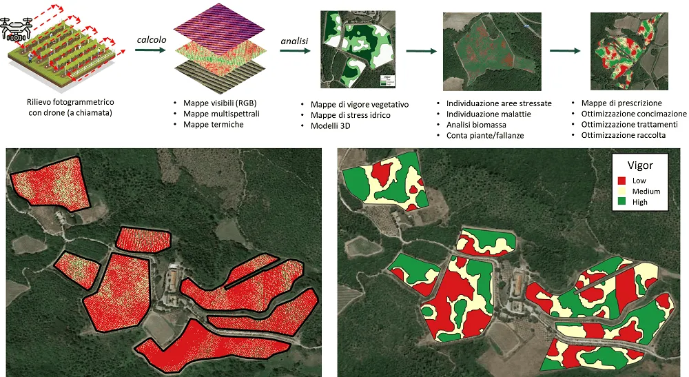
Fig.1: Drone workflow in agriculture (top), vineyard vigour map (left) and vegetative vigour zoning into 3 classes (right)
iDrone: the drone as a powerful ally for the agronomist
Thanks to years of experience in the field, Agrobit offers the iDrone service to help optimise the work of farmers, agronomists and agricultural technicians, reducing survey time and costs through the following methods:
1. Aerial photogrammetry
Drones can be used to carry out aerial visual monitoring of crops, allowing technicians to obtain and build a historical record of a complete, detailed view of plant conditions on a large scale.
Thanks to remotely sensed visible images from drones, it is possible to obtain:
- visible (RGB) maps, which can be used to measure vegetated area, count plants or gaps (Fig. 2), and visually inspect crops
- 3D models (Fig. 2) of crops and the plot, which can be used to measure crop biomass
- digital elevation models (DEM, DSM), also useful when planning new farming or irrigation systems
Repeating flights several times during the season can allow technicians to assess plant growth trends and make any necessary adjustments to crop management operations.
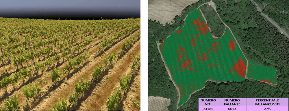
Fig. 2: 3D model of a vineyard (left) and plant and gap count (right)
2. Multispectral maps
Vigour maps are tools used in agriculture to assess crop health and vitality in a detailed, spatially accurate way. These maps provide information on plant vigour, which can be correlated with various factors such as plant health, growth, nutrient uptake and water stress.
Thanks to remotely sensed multispectral images from drones and the use of vegetation indices, it is possible to obtain:
- vigour maps (indices: NDVI, OSAVI), which make it possible to distinguish between more and less vigorous zones within a plot
- chlorophyll maps (indices: GNDVI, NDRE, MCARI, TCARI), to identify stressed and deficient areas
- anthocyanin and carotenoid maps (indices: ARI, CRI), to identify possible stress due to senescence
Depending on requirements, this information can be translated into useful prescription maps, for example, to carry out differentiated fertilisation, treatments or harvesting.
3. Thermal maps
Water stress maps provide spatially detailed information on the level of water stress in plants, allowing technicians to make informed decisions about water resource management and irrigation, for example by setting up a precision irrigation system based on water stress zoning.
Thanks to remotely sensed thermal images from drones and the use of vegetation indices, it is possible to obtain:
- water stress maps (indices: CWSI, NDWI, PRI), to identify water stress or deficiencies in plants
- soil temperature maps, also useful for identifying waterlogging
Conclusions
In summary, using drones makes it possible to carry out accurate mapping of cultivated fields, thanks to greater efficiency and timeliness compared with other manual surveys. Drones can fly over fairly large areas, collecting topographic, thermal and multispectral data to provide detailed information on crop conditions, enabling technicians to make more informed decisions about crop management.
These technologies allow the technician to optimise production, reduce waste and improve the efficiency of agricultural input application, ensuring a faster response to problems such as disease and infestation. They also make it possible to precisely identify variability within the plot, allowing the technician to plan appropriate strategies to reduce this variability (differentiated fertilisation), or suggest a differentiated harvesting strategy for fruit from zones with different vigour characteristics, in order to improve the final product (separate harvesting based on ripeness).
Drone technology can also make a great contribution when it comes to crop protection treatments, in line with the European Green Deal and the Farm-to-Fork strategy, which aim to reduce chemical inputs by 50% by 2030 and achieve ever greater economic, environmental and social sustainability for the agricultural sector. Indeed, drone maps and 3D models make it possible to analyse plants’ biometric characteristics such as thickness, height and volume, making it possible to create prescription maps for differentiated treatments based on the plants’ actual vegetative development. This is also in line with the emergence of new crop protection products that express dosage not only in kg/ha or ml/hl, but also in kg of product per unit of leaf surface area (Leaf Wall Area), i.e. in kg/10,000 m² LWA.