


Objectifies agricultural data for better measurements
iAgro is the DSS app for precision agriculture that turns the smartphone into a collector of agronomic data to optimize crop operations:
– Create the master data for your fields
– Analysis of tree crops (thickness, height, canopy volume)
– Super-local weather forecasts with spraying windows
– 3D models (digital twin)
– Vigor indices (LAI, LWA, TRV)
– Prescription maps for optimized crop operations
– Agronomic reports
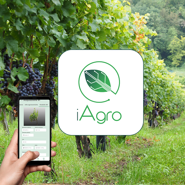
Monitor crops with your smartphone
iAgro is the DSS app for precision agriculture that turns your smartphone into a collector of agronomic data to optimize crop operations and reduce chemical and water inputs by up to 60 percent:
– Create your own field registry
– Tree crop analysis
– Super-local weather forecasts with spray windows
– 3D models (digital twin)
– Vigor indices (LAI, LWA, TRV)
– Prescription maps for optimized crop operations
– Reports
Monitor your experimental evidence from above
The drone is the ideal tool for broad-spectrum, wide-area monitoring of field trials of biostimulants, crop protection products and fertilizers:
– Vegetative maps (vigor, chlorophyll, water stresses)
– Identification of species and varieties
– Identification of stressed areas and diseases
– Measurement of biomass volume
– Plant counting
– Weed mapping
– Aerial treatments
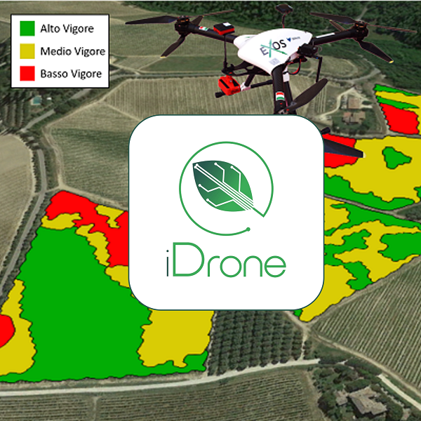
Monitor crops from above
Optimize crop operations and reduce wastage of chemical inputs and water by up to 50% by harnessing the potential of drones through:
– Vegetative maps (vigor, chlorophyll, water stresses)
– Identification of stressed areas and diseases
– Measurement of biomass volume
– Plant and failure counts
– Prescription map for optimized interventions
– Aerial treatments
Monitor the performance of your experimental trials
Get accurate production and yield data of tree crops from chambers mounted on ATVs and tractors:
– Yield map (fruit count)
– Fruit size maps (gauges)
– Fruit color maps
– Flower density estimation
– Estimation of the number of buds
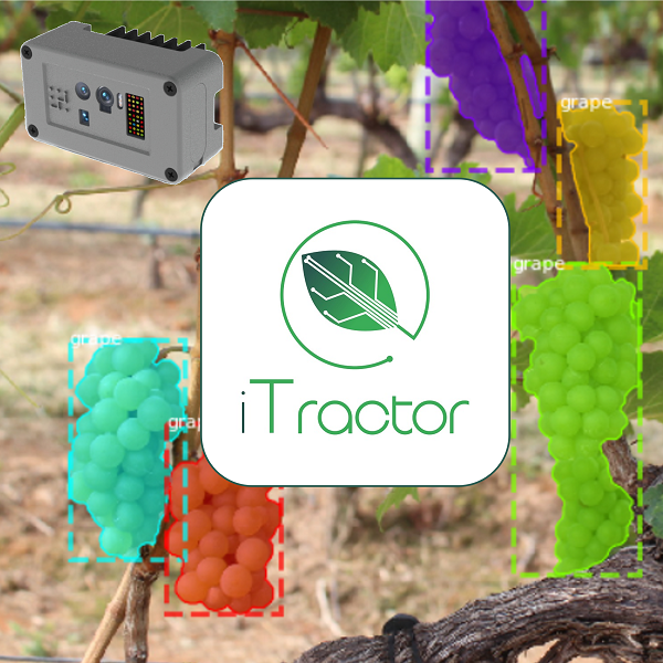
Monitor the yield
Get accurate production and yield data of tree crops from chambers mounted on ATVs and tractors:
– Yield map (fruit counts)
– Fruit size map (calibers)
– Fruit color maps
– Flower density estimation
– Bud number estimation
Manage your crops in one tool
Agricolus is the precision agriculture platform for managing the farm in 360 degrees:
– Remotely monitor fields and adopt targeted strategies
– View vegetation health status with satellite imagery
– Survey plant health status data with weather stations and sensors
– See forecast models for phenology, irrigation, fertilization, insects, and plant disease
– Leverage the Decision Support System to take the most appropriate actions
– Create prescription maps
– Use the app to record information and manage fields from mobile, wherever you are
Manage your businesses in one tool
Agricolus is the precision agriculture platform for managing the farm in 360 degrees:
– Remotely monitor fields and adopt targeted strategies
– View vegetation health status with satellite imagery
– Survey plant health status data with weather stations and sensors
– See forecast models for phenology, irrigation, fertilization, insects, and plant disease
– Leverage the Decision Support System to take the most appropriate actions
– Create prescription maps
– Use the app to record information and manage fields from mobile, wherever you are


Digital tools for the agribusiness supply chain
AgriTrack is the tool for agricultural sector organizations that want to efficiently and innovatively manage the relationship with all stakeholders:
– Ecosystem management
– Innovation and traceability
– Branding and communication
– Multi-farm decision support and agronomic management
– Alert bulletins
– DSS and satellite imagery
– Agronomic management
– Documentation submission
– Reports on farm operations
Monitor the yield
Get accurate production and yield data of tree crops from chambers mounted on ATVs and tractors:
– Yield map (fruit counts)
– Fruit size map (calibers)
– Fruit color maps
– Flower density estimation
– Bud number estimation
They say about us
“Thanks to Agrobit’s drone services, we have been able to improve the nitrogen fertilization of our vineyards to help achieve a better production balance and at the same time avoid creating excesses in the most vigorous areas. In addition, we used the vegetative vigor maps as a support for a more selective harvest thus going on to improve the quality of our wines “
“We have been collaborating with Agrobit for many years, using drone maps to optimize the harvest. By zoning vegetative vigor, we can best select and separate grapes in order to obtain superior wines. With a cost that is more than sustainable even for a small farm like ours (3 hectares), we are able to reap tangible benefits from the technology.”

“With Agrobit’s multispectral camera-equipped drone services, we have been able to map a large part of our vineyards in a short time and accurately. These surveys are extremely useful for x-raying the health of the vineyards and having a greater spatial awareness of the most and least critical areas, which are useful for better targeting agronomic efforts.”
“Thanks to thermal and multispectral drone surveys of our superintensive olive groves, we have been able to map water stresses and criticality, obtaining valuable information for irrigation management. The drone is a unique tool for monitoring hilly territories quickly.”

“We were able to experience firsthand the potential offered by the drone, a tool that can monitor fragmented areas in a short time and at a low cost and can provide us with a unique bird’s-eye view. The vegetative vigor maps were useful for us to assess the status of our vineyards, which have been hit hard by downy mildew, and better direct agronomic efforts to improve productivity.”

“Despite having a reality with about 10 hectares, thanks to Agrobit’s drone services we were able to map the vegetative vigor of our vineyards and optimize fertilization and harvesting. In addition, we were able to objectively verify the effectiveness of certain operations such as inter-row grassing, which is useful for reducing water stress on the rows.”
“Our vineyards are very fragmented and small in size. In this context, where quality is the main objective, the drone with multispectral camera turns out to be a very versatile and quick tool. The data obtained thanks to Agrobit were used to carry out vegetative vigor zoning and objectively assess the state of the vineyards.”

“With Agrobit, we carried out drone flights equipped with a multispectral and thermal camera to get an overhead view of part of our vineyards. The goal was to monitor their condition and water stresses in order to design a precision irrigation system to improve yield.”

“Thanks to Agrobit’s drone flights, we have been able to improve agronomic decisions with objective data, improving fertilization and harvesting.”

“Using Agrobit’s drone and thermal camera flight service, we were able to quickly map temperatures and water stresses in our olive groves and improve irrigation.”
“Thanks to Agrobit’s drone services, we were able to extensively and quickly obtain useful information for our assay center’s field trials. The monitoring capabilities of the drone combined with advanced data analysis algorithms, allowed us to objectively evaluate the effectiveness of the various products tested in the field.”

“We have worked with Agrobit on vineyard, orchard and wheat over several years of experimentation. The services from drone with multispectral and thermal cameras allowed us to assess the functional state of vegetation, which was validated with point measurements on the ground. In addition, we were able to use the mappings to optimize the soil moisture monitoring network by best positioning the FDR sensors on the field under study.”
“We have collaborated with Agrobit on vineyards, olive groves and almond orchards in various experiments related to research projects in the Puglia RDP. The services from drone with multispectral and thermal cameras have been particularly useful, combined with ground-based measurements, for wide-ranging assessment of the health conditions of the plots.”
“We collaborated with Agrobit on vineyard in the Puviot project of PSR Puglia in 3 years of experimentation. Multispectral camera drone services were used to map more than 10 plots between northern Apulia and Salento and assess their vigor status.”