
Case Study: Artificial Intelligence in agriculture, a real application in a citrus grove
Artificial intelligence (AI) in agriculture
What is artificial intelligence?
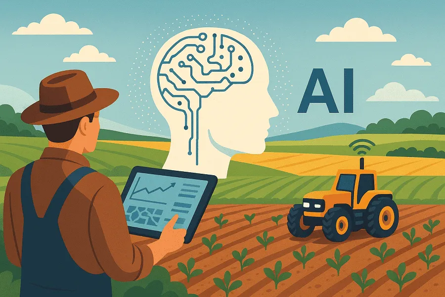
Artificial intelligence (AI) is the ability of a machine to display human capabilities such as reasoning, learning, planning and creativity (European Commission definition, 2018). AI is both a science and an engineering discipline. It is a science because it studies, in theory, how “artificial reasoning” might work. It is engineering because machines or programmes are built that put these capabilities into concrete practice. The main goal of AI is to develop algorithms, models and systems that allow machines to learn from data, draw conclusions, make decisions and solve problems autonomously, as a human would. An AI system works when its performance is measurable and verifiable — for example, if the machine successfully solves a problem, carries out a task or makes decisions according to predefined criteria.

Fig.1: AI: science and engineering.
Machine Learning and Deep Learning
Machine learning and deep learning are two artificial intelligence technologies that are increasingly finding their way into the daily work of farmers and field technicians as practical tools for making better decisions. Machine learning can be described as a system’s ability to “learn from experience”. In practice, the model is fed a large amount of historical data: weather data, production data, soil analysis, crop images, agronomic interventions and their results. By analysing this data, the algorithm automatically identifies recurring relationships, called patterns, and uses them to make predictions or suggest actions. In agriculture, this means, for example, estimating expected yield, predicting the risk of water stress, or identifying conditions favourable to disease development based on real environmental and agronomic data. Deep learning is a subset of machine learning, particularly powerful when working with complex data such as images, signals or highly detailed time series. Its strength lies in the use of “deep” neural networks, inspired by how the human brain works, which can automatically extract the most relevant information from raw data. In an agricultural context, deep learning is what makes it possible, for example, to recognise a leaf disease from a photo taken in the field, distinguish weeds from the crop, analyse a plant’s canopy structure, or assess vigour status from satellite or drone images.
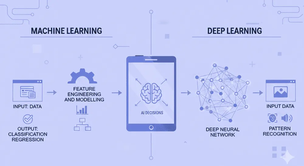
Fig.2: Machine Learning and Deep Learning.
The practical difference between the two approaches is that machine learning works very well when the key variables are already known and measurable, such as phenological data, yield, weather conditions. Conversely, deep learning becomes essential when the information is not immediately numerical but needs to be interpreted, as is the case with aerial images. Often, in the most advanced agricultural applications, the two technologies are combined: deep learning extracts information from images or sensors, and machine learning integrates it with weather, soil and agronomic management data to support the final decision.
Is AI really useful in agriculture?
The value of artificial intelligence emerges above all when it is applied to concrete problems and correctly integrated into a business’s decision-making processes. The usefulness of machine learning and deep learning techniques lies in supporting the farmer in an increasingly complex and unpredictable context, characterised by climate variability, rising production costs, greater regulatory pressure and the need to reduce environmental impact. Today, thanks to the use of on-farm weather stations, satellite and drone imagery, and field or tractor-mounted sensors, agriculture has access to a huge amount of data. This data needs to be turned into information for the farmer, to support them in making informed, valid decisions. One of the crucial points of modern agriculture is the need to act promptly to guarantee the quality and quantity of the final product. Artificial intelligence makes it possible to analyse data from various sources and turn it into operational guidance, such as optimal intervention windows, risk levels or action priorities. This is particularly relevant for activities such as irrigation management, crop protection, nutrition and vegetative status monitoring.
Managing spatio-temporal variability
One of the greatest advantages of using AI is the ability to work with the spatial and temporal variability of agricultural systems. Apparently uniform fields may show significant differences in soil, vigour or phenological development. Thanks to machine learning and deep learning, these differences can be identified and quantified, allowing for targeted interventions and, as a result, more efficient use of water, fertilisers and pesticides. This is a win-win approach: on the one hand, costs are reduced for the farmer, and on the other, social, economic and environmental sustainability is increased. However, it is essential to clarify that the effectiveness of these tools depends heavily on data quality and the correctness of the underlying agronomic model. An algorithm cannot compensate for missing or unrepresentative data, or an incorrect agronomic interpretation of the problem. This is why a multidisciplinary approach is essential: cooperation between farmers, agronomists, technicians and artificial intelligence experts is necessary to ensure the best performance of AI applied to agriculture. Machine learning and deep learning algorithms work best when they are built on solid agronomic foundations and used as support tools, capable of turning large amounts of data into more timely, targeted and sustainable operational guidance.
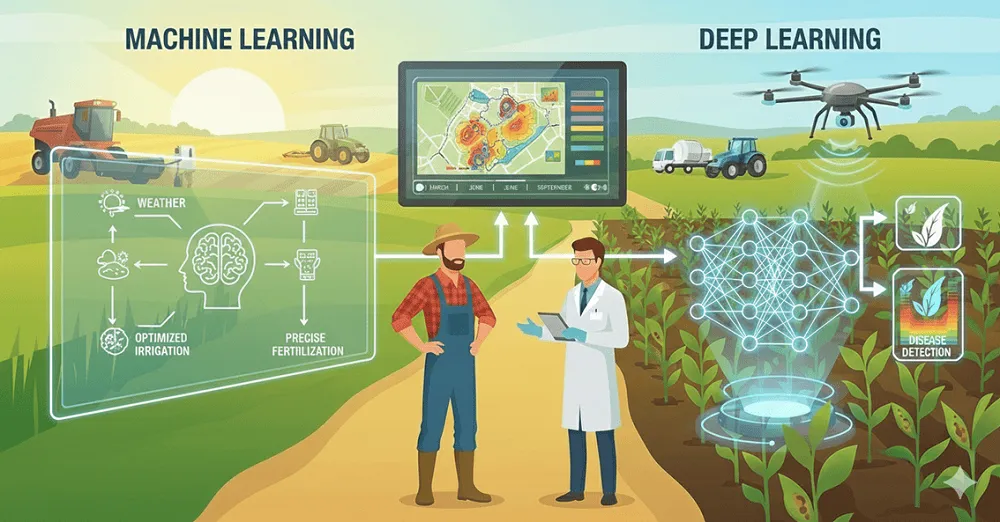
Fig.3: Using Machine Learning and Deep Learning in agriculture requires a multidisciplinary approach.
AI in a citrus grove: a real case study
A concrete example of applying artificial intelligence and digital technologies in agriculture is represented by the multispectral drone analysis carried out on a citrus grove located in Sicily. The aim of the activity was to objectively and quantitatively assess the vegetative status and the plants’ response to different agronomic products (biostimulants), using very high-resolution images and advanced analysis algorithms. The study area was divided into 25 experimental plots of 80 m², each comprising 4 plants. This setup made it possible to obtain comparable, statistically robust data, essential for assessing the effectiveness of the treatments tested and correctly interpreting the citrus grove’s spatial variability. The survey was carried out very quickly using a DJI Mavic 3 Multispectral drone, whose integrated multispectral sensor allows for the simultaneous, aligned acquisition of four spectral bands (green, red, red edge and NIR), as well as a high-resolution RGB image.
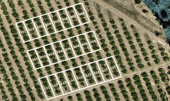
Fig.4: Experimental plots within a Sicilian citrus grove.
Trial results
Starting from the RGB and multispectral images, a 3D model (digital twin) of the citrus grove was recreated. Using this model together with computer vision and AI algorithms makes it possible to automatically extract several biometric and physiological crop parameters, potentially plant by plant: vegetated area, to quantify canopy coverage; canopy thickness, height and volume, direct indicators of vegetative development; vegetation indices, in particular NDVI for vegetative vigour, and GNDVI and NDRE for the indirect estimation of chlorophyll concentration and nutritional status. These parameters result from applying advanced analysis algorithms that turn raw data into agronomic information. Multispectral images, complex by definition, are processed to extract spatial patterns and differences between plots that would be difficult to detect through traditional visual observation. Let’s look at two examples of biometric parameters calculated for the citrus grove. Firstly, vegetated area represents canopy density for each individual citrus plant and is essential for visualising the spatial distribution of density, identifying areas with lower or higher density.
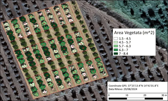
Fig.5: Canopy area for each plant.
The canopy volume map makes it possible to visualise overall canopy development as an average value for each plot. Canopy volume is directly correlated with biomass and reflects what has already emerged from the previous vegetated area map.
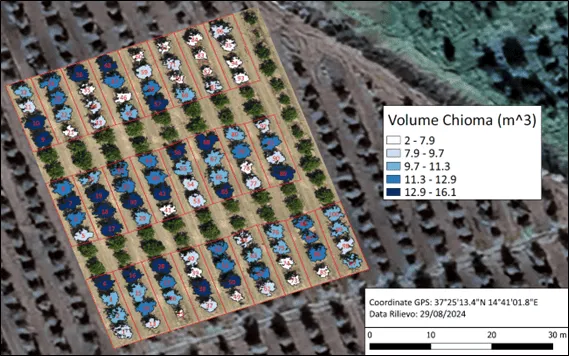
Fig.6: Canopy volume for each plant.
Based on the multispectral information captured by drone, three vegetation indices were calculated: NDVI, GNDVI and NDRE. The NDVI index is strongly influenced by the vigour of the vegetated area, but is equally limited by it, because after reaching a maximum point, it tends to saturate and mask any variability in the field. Intra-plot variability is observed in the citrus grove, as well as variability between plots.
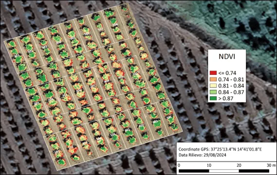
Fig.7: NDVI vegetation index of the canopy for each plant.
The GNDVI map makes it possible to monitor chlorophyll content in crops and better distinguish healthier areas compared with NDVI when canopies are well developed. In addition, GNDVI can be used to assess plants’ water absorption and therefore their water stress. Here too, there is strong variability between plots, while intra-plot variability is reduced.
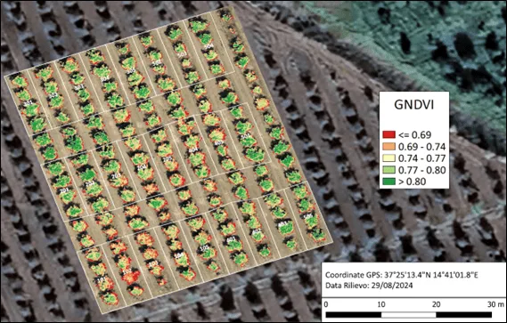
Fig.8: GNDVI vegetation index of the canopy for each plant.
As with the GNDVI index, the NDRE map makes it possible to monitor chlorophyll content in crops, even when canopies are well developed. NDRE is a better indicator of plant health than NDVI for medium and late crops with a high chlorophyll level. In addition, NDRE can be used to assess nitrogen uptake by plants and therefore their efficiency.
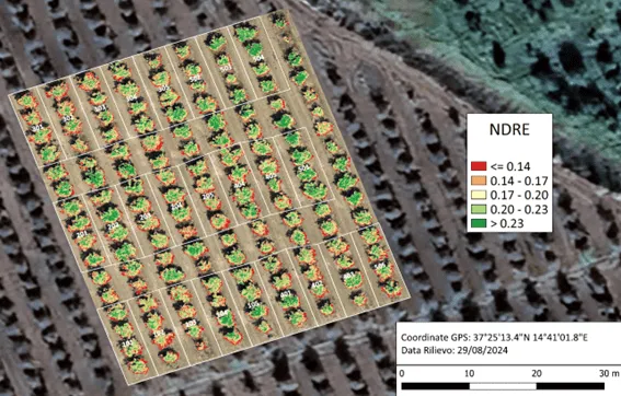
Fig.9: NDRE vegetation index of the canopy for each plant.
Conclusions
The case study carried out in the citrus grove shows that artificial intelligence applied to drone remote sensing can become a concrete operational tool for supporting agronomic decisions. Agrobit’s iDrone service makes it possible to turn very high-resolution multispectral images into objective, measurable information on crop vegetative status. Furthermore, by calculating biometric parameters and vegetation indices, it was possible to identify and quantify the citrus grove’s spatial variability, assess plant response to different treatments and identify stress situations early. This information, difficult to obtain through visual monitoring alone, allows for more targeted, efficient and sustainable interventions. In an increasingly complex agricultural context, the iDrone service represents a reliable AgTech solution for improving management efficiency, reducing costs and supporting decisions based on real data.